
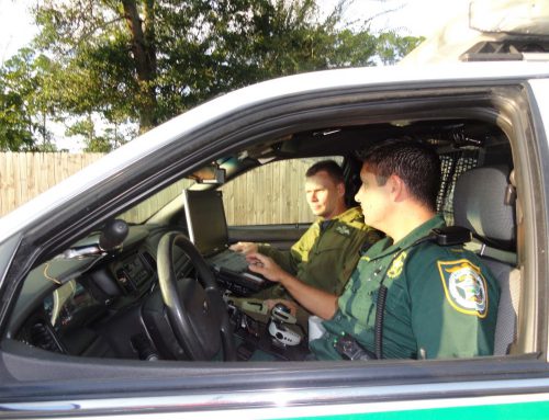
When dealing with emergency incidents, public safety commanders and first responders often have to make split-second decisions. While most fire and police departments communicate via radio, having access to visual information can help agencies manage and respond to incidents more effectively.
According to a 2014 study published by MIT, neuroscientists found that the brain can process images that your eyes see for as little as 13 milliseconds. These findings match other data that suggests humans can identify and understand visual information much faster than data communicated orally or via text.
What does this mean for the public safety industry?
Visual data has many potential applications in the public safety industry. Access to visual information can help firefighters, EMTs, and law enforcement respond efficiently to incidents, have greater situational awareness, and make informed decisions.
Fire Incident Command
One way in which visual data is crucial in the fire service is when it comes to incident command.
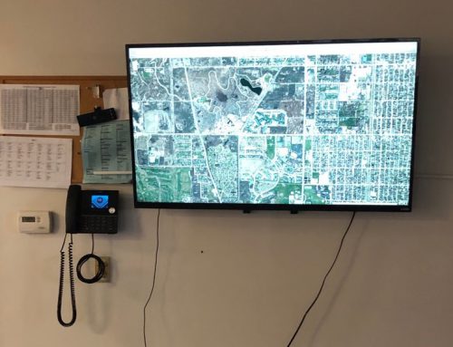
In addition to displaying multiple map views, incident command software can show commanders the location of all units responding to an incident, as displayed in the photo below.
Armed with this information, commanders know which resources they are working with as well as when and where units have arrived, which can set them up for improved asset management.
Instead of relying on complicated radio directions, commanders can see the exact location of their units, which helps them efficiently identify objectives, direct resources, and set up staging areas.
With this improved situational awareness, fire service commanders can use clear, up-to-date visual information to boost tactical planning and informed decision-making.
Incident Mapping
Another visual mapping solution that is affecting the fire service is live incident dashboards. Live incident dashboards allow commanders to view real-time data about emergencies happening in their district and locations close by.

With access to this information, all leaders in the fire service have a clear picture of ongoing incidents in their area. They also can see available resources and deploy them as needed based on proximity and availability.
This can be extremely helpful for dispatching agencies in requesting help from mutual aid partnerships or sending units to large-scale incidents in neighboring jurisdictions. Data on wildfires and other disasters that change locations can help public safety agencies evacuate appropriately and prepare for the spread of fire or hazardous materials.
For law enforcement, several providers are creating software that allows departments to map crimes in their districts and set up operations based on those results. While public safety organizations previously had access to dispatch data, visual maps and guidelines can make it easier to find patterns and identify high-risk areas.
Annotation and Collaboration
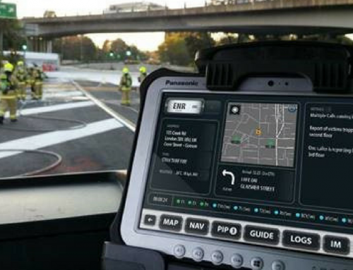
Some types of software also give fire service commanders the ability to annotate and draw on a photo of the incident location or a digital whiteboard, like the telestrator that NFL commentators use during football games.
These annotations then transfer from the commander’s screen to the MDT mounted in the apparatus. With this capability, commanders can essentially “paint a picture” of what’s happening on scene and how first responders should react.
This visual data allows firefighters to see exactly where they need to be. Rather than moving to “the north face of the building”, they can see an image of the precise location where units and resources should go.

Another benefit of visual data in the fire service is when commanders can share floor plan, building entrance and exit points, and fire hydrant locations with their team. The visualization of this data helps personnel have a clearer picture of the situation they’re managing. Distinct information about resources and hazards can also help departments avoid first responder injuries or line of duty deaths.
Some types of software also allow commanders to tap into visual information such as live traffic video feeds from a city or municipal area’s data. These images can provide commanders with improved situational awareness since they have a way to assess the scene and make informed decisions as new developments happen, such as a fire spreading to another part of a building.
Research shows us that humans can process visual data more efficiently than other forms of data, and different people often process images in the same way. This shows us that while visual data has benefits for many industries, it is especially important in the public safety industry.
When public safety officials, first responders, and commanders can quickly communicate and understand data about incidents, they can respond more effectively and avoid loss of life. As new advances are made in public safety technology, we believe that using visual data should be a priority moving forward.
Today’s article was authored by our own Tom Reichstetter, an active fire captain in High Point, North Carolina.
If you enjoyed this article, please check out some of our related posts:
Why Incident Management Technology is Crucial for Command and Control
3 Things Drones Teach Us About Public Safety Technology
Visiting Adashi at FDIC International later this month?
Enter to win a $125 Amazon Gift Card by taking our quick Agency Tech Assessment. Click below to learn more and enter the raffle.


Tom Reichstetter is a member of the Adashi development team, and he also serves as an active fire captain in High Point, North Carolina.


Leave A Comment
You must be logged in to post a comment.